-
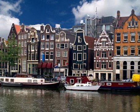
Amsterdam Canals
Amsterdam, capital of the Netherlands, has been called the "Venice of the North" for its more than one hundred kilometres of canals, about 90 islands and 1,500 bridges Read More -
Anne Frank House
The Anne Frank House located on the Prinsengracht canal in Amsterdam, the Netherlands, is a museum dedicated to Jewish wartime diarist Anne Frank, who hid from Nazi persecution with her family and four other people in hidden rooms at the rear of the building. Read More -
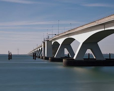
Deltaworks
Flood control is an important issue for the Netherlands, as about two thirds of its area is vulnerable to flooding, while the country is among the most densely populated on Earth. Natural sand dunes and man-made dikes, dams and floodgates provide defense against storm surges from the sea. Read More -
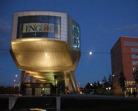
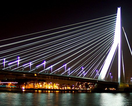
Rotterdam Architecture
Rotterdam is the second-largest city in the Netherlands and one of the largest ports in the world. Rotterdam is also famous for its Kubuswoningen or cube houses built by architect Piet Blom in 1984. In addition to that there are many international well known architects based in Rotterdam like O.M.A (Rem Koolhaas), MVRDV, Neutelings & Riedijk and Erick van Egeraat to name a few. Read More -
Google Maps - Aviation waypoints
A waypoint is a reference point in physical space used for purposes of navigation. Waypoints are sets of coordinates that identify a point in physical space. Coordinates used can vary depending on the application. Read More
-
 Flevoland is a province of the Netherlands. Located in the centre of the country, at the location of the former Zuiderzee, the province was established on January 1, 1986; the twelfth province of the country, with Lelystad as its capital. The province has approximately 394,758 inhabitants (2011) and consists of 6 municipalities.Read More
Flevoland
-
 Gelderland is a province of the Netherlands, located in the central eastern part of the country. Historically, the province (area) dates from states of the Holy Roman Empire and takes its name from the nearby German city of Geldern.Read More
Gelderland
-
 Groningen is the northeasternmost province of the Netherlands. In the east it borders the German state of Niedersachsen (districts of Leer and Emsland), in the south Drenthe, in the west Friesland and in the north the Wadden Sea. The capital of the province is the city of Groningen.Read More
Groningen
-
 Limburg is the southernmost of the twelve provinces of the Netherlands. It is located in the southeastern part of the country and is bordered by the Dutch provinces of Gelderland to the north and North Brabant to the north and northwest, Germany to the east and Belgium to the south and part of the west. Its capital is Maastricht.Read More
Limburg
-
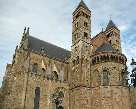
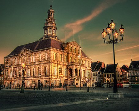 Maastricht is a city in the Netherlands. It is located in the southern part of the Dutch province of Limburg, of which it is the capital.Read More
Maastricht
-
 North Brabant (Dutch: Noord-Brabant is a province of the Netherlands, located in the south of the country, bordered by Belgium's Antwerp and Limburg provinces in the south, the Meuse River (Maas) in the north, and Limburg in the east and Zeeland in the west.Read More
North Brabant
-
 North Holland is a province situated on the North Sea in the northwest of the Netherlands. The provincial capital is Haarlem and its largest city is Amsterdam.Read More
North Holland
-
 Overijssel is a province[1] of the Netherlands in the central-eastern part of the country. The province's name means "Lands across the river Issel", from the perspective of southern Europe. The capital city of Overijssel is Zwolle and the largest city is Enschede. The province has a population of 1,113,529 inhabitants.Read More
Overijssel
-
 South Holland is a province situated on the North Sea in the western part of the Netherlands. The provincial capital is The Hague and its largest city is Rotterdam.Read More
South Holland

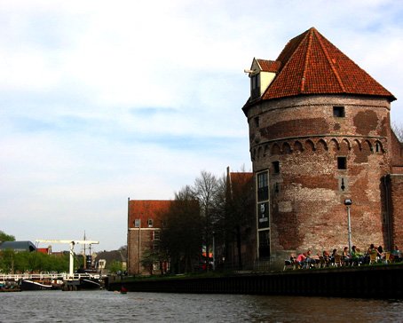
The IJ Amsterdam
- Details
- Category: Amsterdam
The IJ is a lake, formerly a bay, in the Dutch province of North Holland. It is known for being Amsterdam's waterfront. Sometimes it is wrongly considered as a river.
 Dutch people simply call it the IJ, a Dutch word fallen into disuse meaning water. This name derives from the West Frisian word ie "stream, small river" (from Germanic *ahwō "water") and is cognate with Dutch Aa/Ee names for bodies of water. In Dutch, the name consists of the digraph ij, which behaves like a single letter. Therefore, both letters are capitalized; cf. IJmuiden, IJsselmeer.
Geography
Today, the IJ is in two parts, the Binnen-IJ (inner IJ) or Afgesloten-IJ (closed IJ), and the Buiten-IJ (outer IJ). These two lakes are separated by a set of locks.
To the west, the Binnen-IJ is directly connected to the North Sea Canal, where the Port of IJmuiden and the North Sea can be reached.
To the east, the Buiten IJ is an extension of the IJmeer and Markermeer.
History
There are several theories about the origins of the IJ. Perhaps the IJ began as a stream, following a breakthrough in the dunes of Castricum. More likely, the IJ is a remnant of a northern arm of the Rhine delta. Finally, the IJ could also come from the lake Almere or Flevo. During the Roman period the IJ communicated on one side with the lake Flevo and the Vecht (Utrecht) and the other with the North Sea. Connection with the North Sea has subsequently disappeared, while the IJ in the Middle Ages has expanded. This is due to the emergence of the Zuiderzee, itself a bay of the North Sea resulting of a number of storms.
 At the end of the Middle Ages, the IJ was a long and narrow brackish bay that connected to the Zuiderzee and stretched from Amsterdam in the east to Velsen in the west. At its west end, only the natural dune ridge across the Dutch North Sea coast prevented the IJ, which grew ever larger through the centuries, from directly connecting to the North Sea and so making the North Holland peninsula nearly an island. By the seventeenth century, however, access to the IJ became difficult due to sand bars across its mouth, and ships becoming bigger, and it was nearly impossible for seafaring vessels to reach the city. At the same time, the bay gnawed away at the surrounding farmlands, almost connecting with the Haarlemmermeer (Lake Haarlem) and seriously threatening the cities of Haarlem and Amsterdam.
Plans were put forth to reclaim both the Haarlemmermeer and the IJ and turn them into polders. The Haarlemmermeer was first, falling dry in 1852, and the largest part of the IJ followed suit between 1865 and 1876, with only a small lake remaining at Amsterdam that was closed off from the Zuiderzee by the Oranje locks. At the same time, the North Sea Canal was constructed in the former IJ basin to provide Amsterdam with access to the sea again and revive its ailing port. It cut through the isthmus to connect to the North Sea near the town of Velsen; a new port, IJmuiden ("Y-mouth") was built at its west end. The east end of the IJ polders near Amsterdam was given over to industry, and a large new seaport area was constructed.
The Buiten IJ hosted the mixed dinghy sailing events for the 1928 Summer Olympics in neighboring Amsterdam. It also hosted two events for the 1920 Summer Olympics in Antwerp.
Latest articles
- Accommodatie Eurovisie Songfestival 2020 - Rotterdam
- Vermeer - famous Dutch painter from Delft
- Delft - Oude Kerk - Old Church
- Delft
- Enkhuizen - Havenweg - streetview - Google Maps
- Alkmaar - cheese market - Waagplein - streetview - Google Maps
- Hoorn - city center - Roode Steen - streetview - Google Maps
- Veere - Townhall - streetview - Google Maps
- Middelburg - Townhall - streetview - Google Maps
- Vlissingen - Smallekade - streetview - Google Maps
- Zierikzee- streetview - Google Maps
- Oosterschelde- streetview - Google Maps
- Haringvlietdam - Haringvlietsluis - streetview - Google Maps
- Hollands Diep - streetview - Google Maps
- Moerdijk bridges - streetview - Google Maps
- Harlingen - streetview - Google Maps
- Stavoren - streetview
- Dokkum - streetview
- Giethoorn - streetview
- Claire Morgan The Sound of Silence - Noord Brabants Museum
Visitors for Visitholland
We have 158 guests and no members online